
Initial Report Into Signal Cartel’s Survey of the Anoikis Cluster and the ‘Shattered Systems’ – report by A Dead Parrot (authorised for public release 9/24/119)
Ever since the Seyllin Incident and its related ‘Main Sequence Events’ that triggered the opening of the first wormholes in YC 111, New Eden scientists have been debating the physical location of the Anoikis Cluster relative to New Eden. As a result, several serious attempts to accurately map Anoikis have paved the way for what we know today.
The first major attempt to do so was conducted during YC113 as an Arek’Jaalan project led by the Intaki capsuleer-scientist Mark726, using the designation Project Compass. The Distant Stellar Object Data Capture (DSODC), using images captured in wormhole space from camera drones, relied on the principles of parallax and spectroscopy to determine just where in space each image was located. It attempted to “ascertain whether the same distant stellar or extra-galactic point sources could be identified in both Anoikis and New Eden” through space photography.
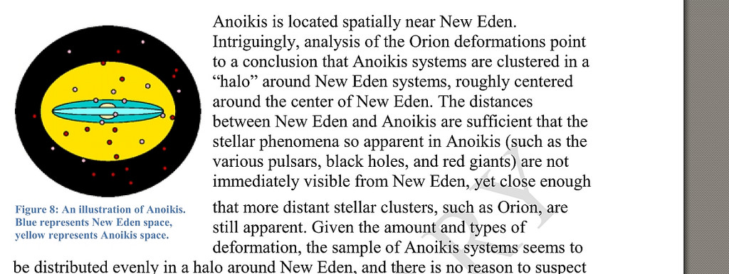
However, this early attempt incorrectly determined that New Eden was located in the center of the known universe and that the Anoikis Cluster surrounded it, like an outer shell.
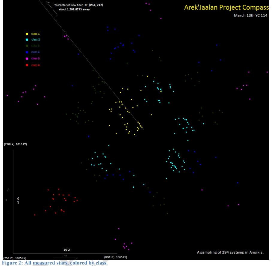
Following this attempt, with the discovery of the locator functionality of starbase control towers placed in space, Mark726 and Faulx launched Project Compass 2.0 which would again attempt to locate and map the Anoikis Cluster. This time, project researchers would use the triangulation of distance measurements collected from a small constellation of five control towers placed as far apart as possible in New Eden. Their conclusions were quite different (and contradictory) to those of Project Compass 1.0.
Project Compass 2.0 concluded that New Eden was in fact not at the center of the known universe surrounded by Anoikis, but instead, Anoikis was located in an entirely distinct area of space separated by a distance of almost 1,300 light years from New Eden.
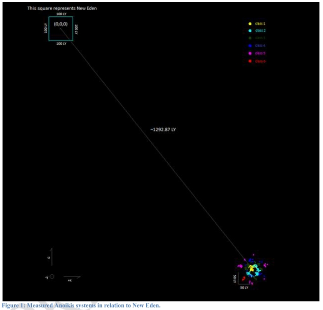
In addition, Project Compass 2.0 was actually able to determine a rough map of Anoikis itself, using a relatively small sampling of less than 300 systems located by painstakingly triangulating their distances from each control tower in the measurement array. As of 3/13/YC114, those control towers ceased providing distances to systems in Anoikis.
Some years later, during YC117, an independent researcher by the name of Alyxportur was able to put together a detailed static map of the Anoikis Cluster which appeared to confirm the findings of Project Compass 2.0. You can see, in his images below, the roughly hexagonal shape of the Anoikis Cluster, similar to the conclusions reached by Project Compass 2.0.
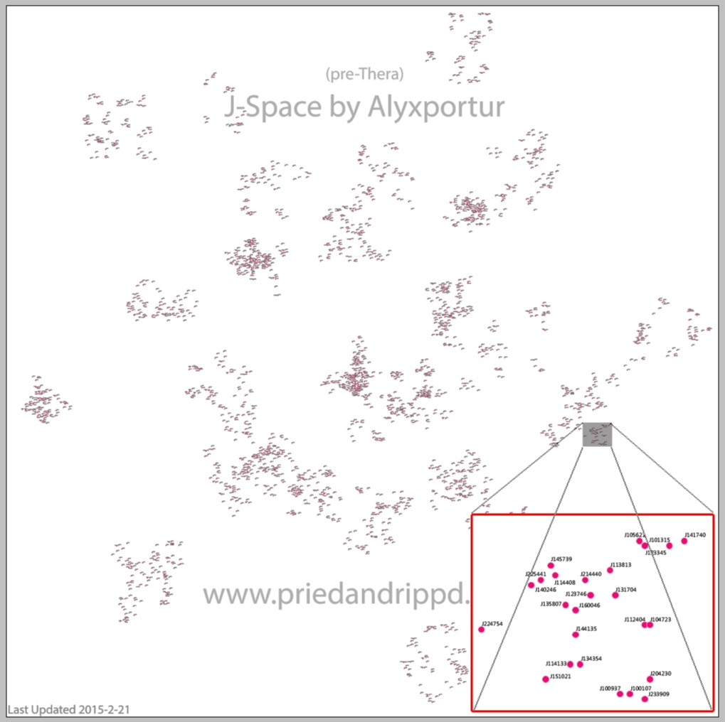
However, at that time, Alyxportur’s findings were criticized by the scientific community and he was in fact belittled by many who said he was merely repeating research that had already been done years earlier through Project Compass 2.0. But few actually comprehended the computational methods he used to produce his results. The Anoikis Cluster had not yet been mapped with that level of detail.
Unfortunately, Alyxportur may have been discouraged by the community’s unwillingness to appreciate his work and his research was abandoned, at least in the public eye.
It is important to note at this point that both Alyxportur and the researchers involved with the earlier Project Compass 2.0 completed their work using data obtained prior to the discovery of the Thera system, and were likely to be unaware at the time that they were only mapping what we now refer to as the Anoikis ‘main cluster’, as they had no maps, data, or even knowledge of the existence of Thera and the so-called ‘shattered systems’ that were discovered later.
Fast-forward to today. Through the work of Signal Cartel researchers including myself and hundreds of other Signal pilots engaged in ongoing deployments throughout the Anoikis Cluster, aided in no small part by discoveries made possible by the creation of Signal Cartel’s ALLISON navigational AI [1], a modern picture of the relative positions of the Anoikis Cluster, Thera, the shattered systems, and their combined spatial relationship to the New Eden Cluster are becoming clearer than they ever were. Who knows what future discoveries will unveil.
Based on the dataset gathered by Signal Cartel as described above, I therefore present below a preliminary hypothesis concerning the true, accurate spatial relationship between the Anoikis Cluster and the ‘shattered systems’. See the notes embedded in each document for further details on the measurement methods involved, together with expanded text on the overall hypothesis.
First: the Anoikis Cluster and its position relative to the ‘shattered systems’. The dataset indicates that the two clusters are not co-located at all, and are in fact separated by a considerable distance:
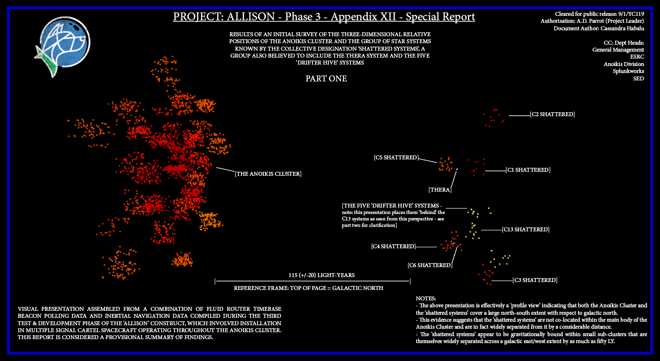
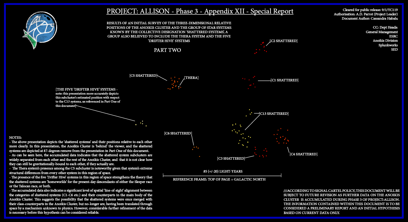
Second: the positions of the ‘shattered systems’, the Thera system and the five ‘Drifter Hives’ relative to each other. Again, these star systems are separated from each other by a great distance, but appear to be co-located along a specific ‘flat plane’ with respect to the galactic centre [note: this is also true of the main Anoikis Cluster: neither can be considered a globular cluster]. There is also a tantalising pattern within the dataset that suggests a high degree of line-of-sight alignment between the ‘shattered systems’ and certain stars in the main Anoikis Cluster (see document text for further explanation).
Further research and refinement of this dataset is ongoing, and more results will be published as and when reliable conclusions can be formed.
[ENDS]
Notes:
[1] The ALLISON construct is a prototype artificial intelligence that I designed, and it is installed on all Signal Cartel spacecraft as a matter of standard operating procedure. Its principal purpose is to enhance the capsuleer’s navigational situational awareness to unprecedented levels and has proved extremely successful. Its use during the project described above was crucial as it was effectively a form of parallel processing capability combined with ultra-long-baseline interferometry, as if several hundred Project Compasses were operating simultaneously.
The above paper is © A Dead Parrot. Attribution to external sources is given in the text. All opinions stated are those of the author. All rights reserved. The Project: ALLISON Phase 3 reports are © Cassandra Habalu.
Media Enquiries: for further information, feedback, or media bookings and interview requests, please contact A Dead Parrot via Signal Cartel management or please leave comments in the space provided below. We look forward to hearing from you.